registrar@dibru.ac.in  
        registrar@dibru.ac.in  

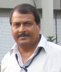
Dr. Uttam Goswami

Former Professor, Department of Applied Geology
  • Email - ugoswamidu@gmail.com
  • Phone No. - 09954480932
  • Department of Applied Geology
  • Designation - Former Professor

Profile

Educational Qualifications: M.Tech., Ph.D.


Specialization: Hydrogeology and Fluvial Geomorphology

Contact
Phone No:2370247

Mobile No:09954480932

E-mail:ugoswamidu@gmail.com, goswamiuttam@yahoo.co.in

Area of interest

  • Groundwater exploration, development and management; River studies; Petroleum exploration and Oil well drilling.

Papers taught

  • M.Sc. (Applied Geology Course) : Hydrogeology (full paper); Exploration of oil and gas deposits (half paper).
  • M.Tech. (Petroleum Geology Course): Oil well drilling (full paper); Geochemisty in petroleum exploration (1/4 th papaer).
  • M.Tech. (Exploration Geophysics Course): Hydrogeology (Optional Paper)


Publications

1.      Komargaon , Assam (India) Witnessed a New Metweorite Fall.  PLANEX, Vol.6, Issue 1,  pp 10-11, January 2016 (ISSN: 2320-7108).


2.     Spatial Variability of Groundwater Chemical Quality for Drinking and Irrigation Purposes in parts of Nagaon and Morigaon Districts, Assam, using Geoinformatics. International Journal for Research in Applied Science & Engineering Technology (IJRASET),2015, Vol. 3, Issue III, 372-382, March 2015 (ISSN: 2321-9653).


3.     Ground Water Resource Potential of the Shallow Aquifer Regime in the Lower Subansiri Basin, N.E. India.Jour. of Earth Scies., Special Vol.:Multidisciplinary Approach in Sedimentary Basin Analysis, 307-313; Dept. of App. Geol., Dibrugarh Univ., Dibrugarh, Dec. 2013 (ISSN 2347-8942).


4.     Drainage analysis in a part of the lower subansiri basin, North-East India.Jour. of Earth Scies., Special Vol.: Multidisciplinary Approach in Sedimentary Basin Analysis, 162-167; Dept. of App. Geol., Dibrugarh Univ., Dibrugarh, Dec. 2013 (ISSN: 2347-8942).


5.     Visual change detection study of some of the urban areas of Assam, India, using remote sensing. International Journal of Geomatics and Geosciences, 2013, Integrated Publishing Association,Vol. 3 No. 3, 500-510,March 2013 (ISSN: 0976 – 4380).


6.     Morphometric analysis of the Sisi river basin, North-East India and some geo-environmental implications. PARIPEX- Indian Journal of Research, 2012, Vol 1, Issue 4, 5-7, April, 2012 (ISSN: 2250-1991).


7.     Study of Fluvial Geomorphic Features of the Lower Subansiri Basin, North-East India using Remote Sensing and GIS. Indian Journal of Applied Research, 2012, Vol 1, Issue 7, 12-14, April 2012 (ISSN: 2249 -555X).


8.     Assessment of hydrological properties of soils from textural analysis: a study in the Burhi Dihing-Noa Dihing interfluves, Assam. PARIPEX- Indian Journal of Research, Vol 1, Issue 3, 4-7, March 2012 (ISSN: 2250-1991).


9.     Ground Water Prospect in the adjoining areas of the Belt of Schuppen: Kharsang Oilfield Area of Arunachal Pradesh, North-East India. International journal of Geomatics and Geosciences, 2012, Integrated Publishing Association, Vol-2, No. 3, 787-804, February 2012 ((ISSN: 0976 – 4380).


10.   Hydrogeologic Settings of the North and South Brahmaputra Plains in Upper Assam: A Comparative Study. Indian Journal of Applied Research,2012, Vol 1, Issue 5, 98-100, February 2012 (ISSN: 2249 -555X).


11.   Geochemical  characterization of soils and ground water occurring within the shallow subsurface zones in parts of the interfluves between Noa Dihing and Burhi Dihing rivers, Assam. Jour. of Chemistry and Chemical Sciences, 2011, Vol 1, Issue 2, pp 137-149.


12.   Delineation of paleochannels in the interfluves around Burhi Dihing River, Assam, using remote sensing data. E-Journal: CTRGA 2007- Conference on Current Trends in Remote Sensing and GIS Applications, 15-17-Feb 2007,  IIT Kharagpur, India.


13.   Change of river channel and bank erosion of the Burhi Dihing River (Assam), assessed using remote sensing data and GIS. Photonirvachak : Jour. Ind. Soc. Remote Sensing, 2007, Vol. 35, No.1, pp 93-100.


14.   Hydrogeologic and geomorphic settings of the Lower Subansiri basin, Assam, India. Jour. Nepal Geol. Soc., 2002, V- 27 (Special Issue), pp. 53-63, Kathmandu, Nepal.

<span style="font-size: 10.0pt; font-family: 'Arial','sans-serif'; mso-fareast-font-family: 'Times New Roman'; color: black; mso-fareast-language: E

Profile

Profile

Educational Qualifications: M.Tech., Ph.D.


Specialization: Hydrogeology and Fluvial Geomorphology

Contact
Phone No:2370247

Mobile No:09954480932

E-mail:ugoswamidu@gmail.com, goswamiuttam@yahoo.co.in

Area of interest

  • Groundwater exploration, development and management; River studies; Petroleum exploration and Oil well drilling.

Papers taught

  • M.Sc. (Applied Geology Course) : Hydrogeology (full paper); Exploration of oil and gas deposits (half paper).
  • M.Tech. (Petroleum Geology Course): Oil well drilling (full paper); Geochemisty in petroleum exploration (1/4 th papaer).
  • M.Tech. (Exploration Geophysics Course): Hydrogeology (Optional Paper)


Publications

Publications


1.      Komargaon , Assam (India) Witnessed a New Metweorite Fall.  PLANEX, Vol.6, Issue 1,  pp 10-11, January 2016 (ISSN: 2320-7108).


2.     Spatial Variability of Groundwater Chemical Quality for Drinking and Irrigation Purposes in parts of Nagaon and Morigaon Districts, Assam, using Geoinformatics. International Journal for Research in Applied Science & Engineering Technology (IJRASET),2015, Vol. 3, Issue III, 372-382, March 2015 (ISSN: 2321-9653).


3.     Ground Water Resource Potential of the Shallow Aquifer Regime in the Lower Subansiri Basin, N.E. India.Jour. of Earth Scies., Special Vol.:Multidisciplinary Approach in Sedimentary Basin Analysis, 307-313; Dept. of App. Geol., Dibrugarh Univ., Dibrugarh, Dec. 2013 (ISSN 2347-8942).


4.     Drainage analysis in a part of the lower subansiri basin, North-East India.Jour. of Earth Scies., Special Vol.: Multidisciplinary Approach in Sedimentary Basin Analysis, 162-167; Dept. of App. Geol., Dibrugarh Univ., Dibrugarh, Dec. 2013 (ISSN: 2347-8942).


5.     Visual change detection study of some of the urban areas of Assam, India, using remote sensing. International Journal of Geomatics and Geosciences, 2013, Integrated Publishing Association,Vol. 3 No. 3, 500-510,March 2013 (ISSN: 0976 – 4380).


6.     Morphometric analysis of the Sisi river basin, North-East India and some geo-environmental implications. PARIPEX- Indian Journal of Research, 2012, Vol 1, Issue 4, 5-7, April, 2012 (ISSN: 2250-1991).


7.     Study of Fluvial Geomorphic Features of the Lower Subansiri Basin, North-East India using Remote Sensing and GIS. Indian Journal of Applied Research, 2012, Vol 1, Issue 7, 12-14, April 2012 (ISSN: 2249 -555X).


8.     Assessment of hydrological properties of soils from textural analysis: a study in the Burhi Dihing-Noa Dihing interfluves, Assam. PARIPEX- Indian Journal of Research, Vol 1, Issue 3, 4-7, March 2012 (ISSN: 2250-1991).


9.     Ground Water Prospect in the adjoining areas of the Belt of Schuppen: Kharsang Oilfield Area of Arunachal Pradesh, North-East India. International journal of Geomatics and Geosciences, 2012, Integrated Publishing Association, Vol-2, No. 3, 787-804, February 2012 ((ISSN: 0976 – 4380).


10.   Hydrogeologic Settings of the North and South Brahmaputra Plains in Upper Assam: A Comparative Study. Indian Journal of Applied Research,2012, Vol 1, Issue 5, 98-100, February 2012 (ISSN: 2249 -555X).


11.   Geochemical  characterization of soils and ground water occurring within the shallow subsurface zones in parts of the interfluves between Noa Dihing and Burhi Dihing rivers, Assam. Jour. of Chemistry and Chemical Sciences, 2011, Vol 1, Issue 2, pp 137-149.


12.   Delineation of paleochannels in the interfluves around Burhi Dihing River, Assam, using remote sensing data. E-Journal: CTRGA 2007- Conference on Current Trends in Remote Sensing and GIS Applications, 15-17-Feb 2007,  IIT Kharagpur, India.


13.   Change of river channel and bank erosion of the Burhi Dihing River (Assam), assessed using remote sensing data and GIS. Photonirvachak : Jour. Ind. Soc. Remote Sensing, 2007, Vol. 35, No.1, pp 93-100.


14.   Hydrogeologic and geomorphic settings of the Lower Subansiri basin, Assam, India. Jour. Nepal Geol. Soc., 2002, V- 27 (Special Issue), pp. 53-63, Kathmandu, Nepal.

<span style="font-size: 10.0pt; font-family: 'Arial','sans-serif'; mso-fareast-font-family: 'Times New Roman'; color: black; mso-fareast-language: E
Courses Taken
Current Courses
Sponsored Projects